
by Conall Mac Aongusa, Transport Planner, 1/7/2019
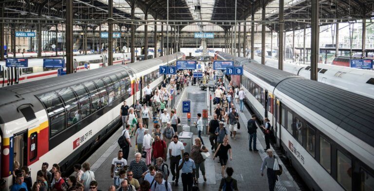
The Hauptbahnhof or Main Railway Station in Frankfurt is situated in the centre of the city adjacent to the main square amid bustling activity of buses trams passengers and car traffic. The streets and footpaths surrounding the station are crowded with streams of people coming and going from the station and from the retail shops bars cafes and hotels in its vicinity. The station is a hive of activity for 24 hours of the days with local trains serving the immediate city region, U-Bahn or metro trains serving the central area and long-distance intercity trains connecting Frankfurt with other cities in Germany and beyond as far as Paris Amsterdam Berlin, Warsaw and Moscow.

It is an example of a well-located train station integrated with its surroundings serving the city and facilitating easy interchanges between services while ensuring access to the centre of urban life. But such a station and a hub of coordinated urban activity do not occur by accident.
Railways and railway stations are generators of economic activity linking cities towns and villages across regions countries and continents. Deciding which cities and towns to connect and where to place and build the stations is to make an economic decision about where growth and activity in the urban area is likely to occur. But on the other hand if the railway station is built in the wrong place – and it is not near a centre of population or is not easily accessible then passengers will not use it and the railway patronage will not grow and this will ultimately damage the railway business.
There are many examples of stations located in the wrong place – for example in South Bend, Indiana in the USA the new train station was rebuilt 3 miles from outside the city so the old station could be redeveloped as a commercial centre, the legacy of poor decision making in the 1960s. This was a missed opportunity for the city as the train business never grew as passengers had no easy way to reach the train station and over time chose the car over the train, the passenger throughput declined.
Historically the purpose and intention of the railway planner and developer is a critical factor in deciding where the railway is built. For example in India the main purpose of much of the railway network, when planned in the 19th Century, was to link resource-rich areas producing goods for export with the ports in the coastal area. As a result, the railway was never designed to meet the travelling needs of the Indian population and many stations nowadays are located at an inconvenient location some distance from the urban centre. A similar pattern occurred in Ireland where the locations of railway stations in a many provincial towns were placed outside the town centre by the original developers in the 19th century meaning that passengers and merchants had to bring their goods by other means some kilometres outside the town to meet the train connections to the larger cities of on the coast. Over time the demand for the railway could not compete with the motor car and demand for the railway did not grow. But perhaps more importantly unlike the pattern observed elsewhere in Europe the towns did not grow around the railway station and the activities and economic potential of the railway was never fully integrated with the town and the opportunity was lost.
In the modern era mistakes continue to happen – for example, RATP in Paris admitted in 2017 that a railway station in Yvelines was built “in the wrong place” when they underestimated of the rate of urban growth – a new station is now planned. In the East Midlands in the UK a station built in 2009 is now considered to be “in the wrong place” because it is too far away from the developing airport and is not attractive for passengers. Better planning would resolve these dilemmas. It is now best practice to plan the location of railways and railway stations in an integrated with urban areas so as to maximise the economic and social benefits of improved access and connectivity for passengers and goods. For example, the planning of land use and transport starts at the national level with the national spatial strategy which identifies and coordinates the planned and future use of land and infrastructure to achieve the national economic and social goals. This includes ensuring the railways and other transport services are planned to link places of economic and social activity in accordance with an integrated land use and transport plan.
The Dutch “ABC land use planning policy” is effective in setting the rules for deciding where a new railway station or transport facility or service can be located. For example, it does this by identifying what should the permitted land uses be in the vicinity of the railway station. This favours the location of commercial and retail and residential activities near a railway station rather than industrial or warehousing activities.
The development of railways can bring major economic and social benefits to regions and countries and the location of railway stations are critical to ensure that the maximum number of passengers can access the railway and that other services can connect with the railway. A well-planned railway system should link major population centres and the railway stations should provide good interchange with other transport services and provide good access to the centre of the urban centre.
A well-planned railway system and well-located railway stations do not happen by accident – they require attention to the careful integration of transport planning and land use.